The first attempt to make an accurate…

The first attempt to make an accurate world map was by an astrologer (Claudius Ptolemy, second century CE) so that he could chart the relationship between the person’s birthplace and the heavenly bodies. While doing so, he coined the term “geography”.

15 Interesting Finds from Google Earth

I can spend endless hours on Google Earth.

An Imgur user who also happens to be a geologist with the username “geologistsmakethebedrock” spent a lot of time on the site and posted some of his most interesting finds.

Take a look, these are fascinating!

1. “A fort in Lille, France.”

Photo Credit: Google Earth

2. “This is a private island on the coast of Maine.”

Photo Credit: Google Earth

3. “It looks like an abstract painting. My first thought was a huge archeological excavation site. Turns out that was wrong. These pits are used in a very old fashioned salt extraction operation.”

Photo Credit: Google Earth

4. “A very sinuous river. This is a good illustration of how oxbow lakes form. In the middle of the image you can see where a meander loop is being actively cut off.”

Photo Credit: Google Earth

5. “A real live oasis!. Not all of these tracks are from cars. The smaller ones must be animal.”

Photo Credit: Google Earth

6. “Here is a perfect meteor crater. It has a very nice raised rim. I bet if you mapped out the lake bed you would see a central peak too.”

Photo Credit: Google Earth

7. “I couldn’t find anything about this strange place. It’s a huge, planned settlement near Namibe, Angola.”

Photo Credit: Google Earth

8. “The circular reflections of these waves are cool.”

Photo Credit: Google Earth

9. “This is Assamakka, Niger, a community that appears to be fighting a losing battle with the sands.”

Photo Credit: Google Earth

10. “I wanted to see if I could find a ship wreck. I figured a desert coast would preserve metal wrecks well. It didn’t take to long to find this one in NW South Africa. It looks like a modern ship, and sure enough it wasn’t there in 2003 (the oldest picture available).”

Photo Credit: Google Earth

11.”A river cutting a hole in the ice.”

Photo Credit: Google Earth

12. “This is the Lakeview neighborhood. One day after Hurricane Katrina.”

Photo Credit: Google Earth

13.”This is some sort of reservoir in Belgium. I’ve never seen an octagonal pond before. I wonder why they made it that way.”

Photo Credit: Google Earth

14.”A lake somewhere on the Tibetan Plateau in summer and winter.”

Photo Credit: Google Earth

15. “A volcano poking up out of the South Pacific. I’m not sure if this one is growing or eroding away.”

Photo Credit: Google Earth

Now I’m in the mood to see the world!

The post 15 Interesting Finds from Google Earth appeared first on UberFacts.

This Map Compares the Education Level in Each State to a Corresponding Country, and it’s Offending Everyone

We all know Americans like to think they’re number one at just about everything, but the truth is…that’s just not the truth. In fact, perhaps it’s their low education levels that makes them believe such a thing in the first place!

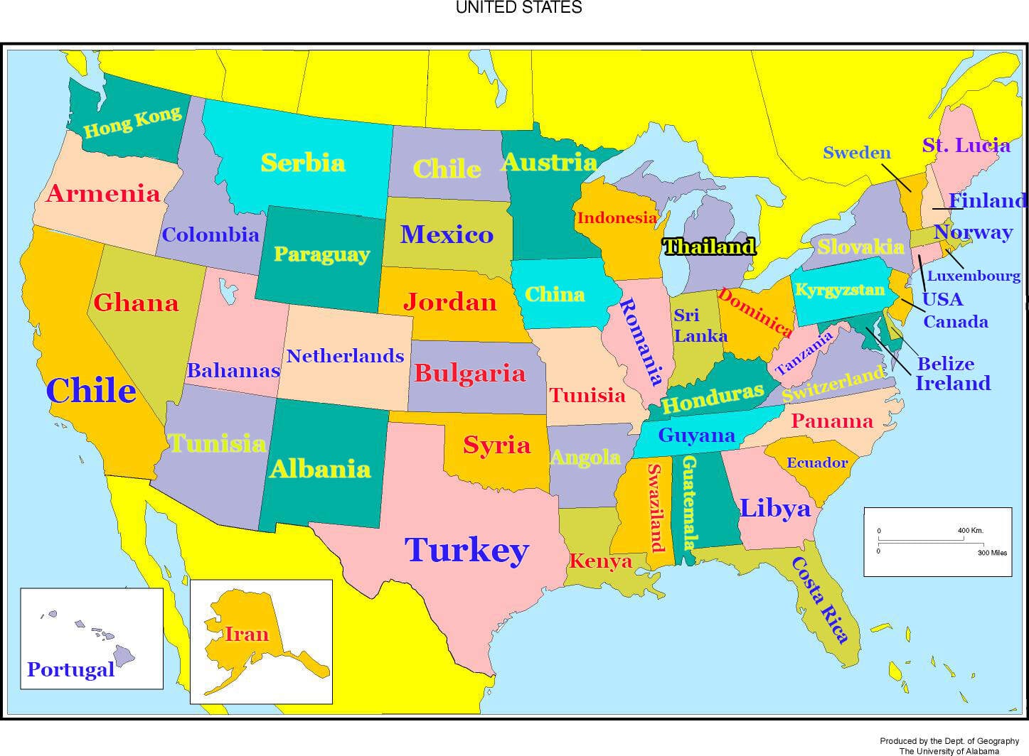
According to the Organization for Economic Cooperation, American students rank 28th in math and science scores (for those not good at math, it means there are 27 better countries). The educated people at Home Snacks made a map of the United States comparing each state with a foreign country that is said to have similar education levels, using the United Nations Development Program index. Understanding this map will take knowledge of both United States and world geography, which means you’ll most likely get it if you live in the Northeast.

usmapfinal-YkBDxY
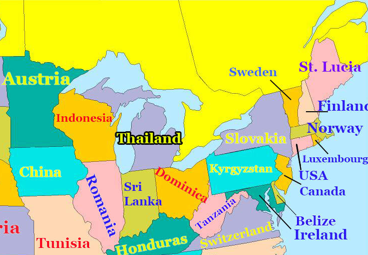
Here it is zoomed in, if that helps you focus.

northeast-U6y9NP
The Northeast and Midwest tend to be on a similar track as European countries.

southeast-DRuiDL
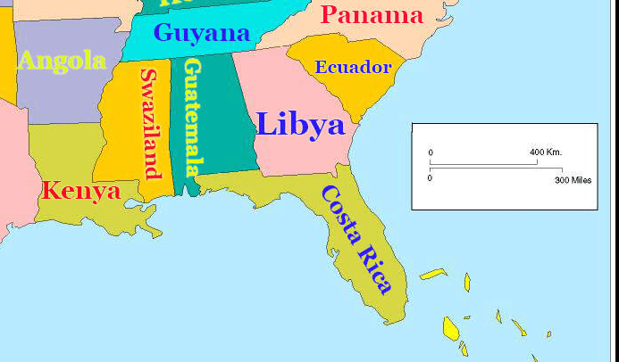
While the Southeast is largely comparable to Central America and Africa.

northwest-gvINkk
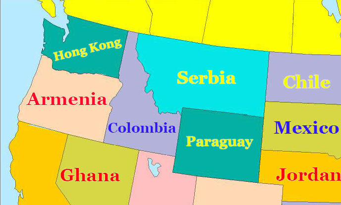
The Northwest appears to be the most diverse.

southwest-huy8N7
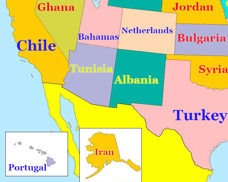
Although the Southwest is pretty diverse in its own right.

I guess like everything else in America, there are advantages and disadvantages to living in every nook and cranny of the country – but I’m not placing any bets on people deciding to forgo their home state for better education grounds anytime soon.

(h/t: Someecards)

We know you can choose a lot of sites to read, but we want you to know that we’re thankful you chose Did You Know.

You rock! Thanks for reading!

The post This Map Compares the Education Level in Each State to a Corresponding Country, and it’s Offending Everyone appeared first on UberFacts.

There is a fictional island in the South Atlantic…

There is a fictional island in the South Atlantic, off the west coast of Africa, at lat/long 0,0, called ‘Null Island’. Although it doesn’t exist in reality, it serves as an error trap for map systems. Map enthusiasts have given the island its own history, geography and even flag.