There are two types of people out there – people who love a good road trip and can’t resist the call of the open road, and people who have no souls.
I jest, I jest (or do I?), but seriously, what’s better than a car to yourself, a good album or audiobook or podcast on the radio, and no established time that you have to reach your destination? Oh, and don’t forget the gas station snacks on the passenger seat…
What could be better than that?
Image Credit: iStock
Maybe if you had all of that plus perfect, windows-rolled-down weather outside?
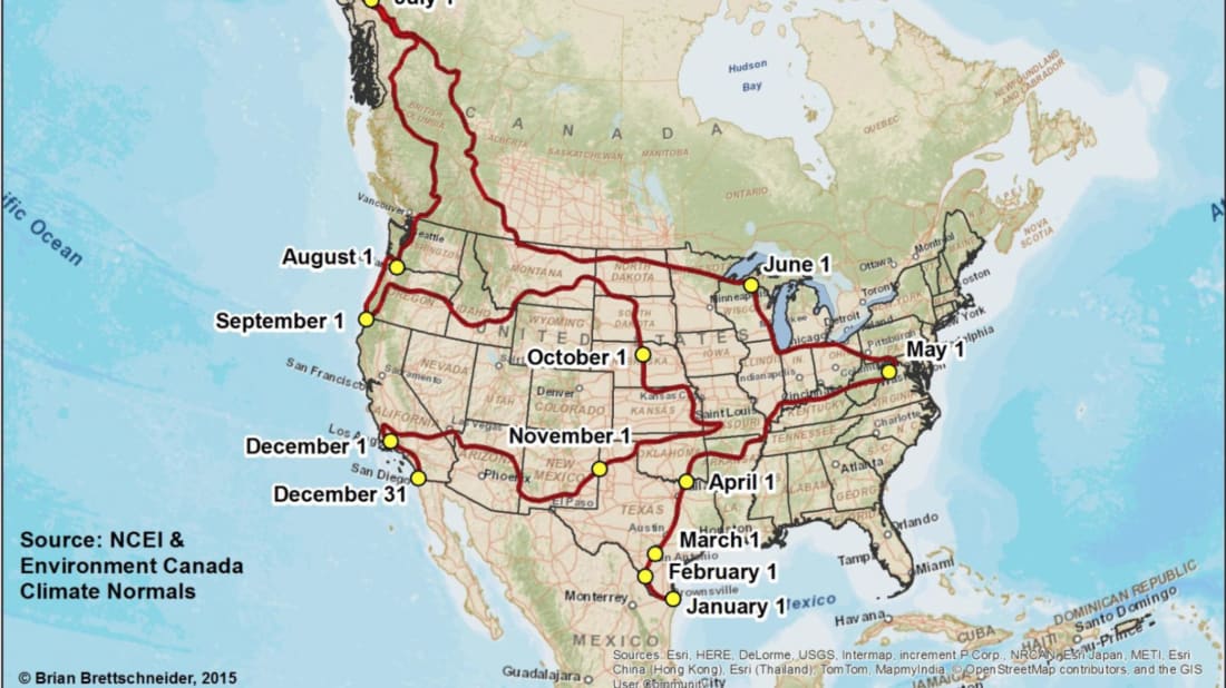
That’s exactly what you’ll get if you follow this epic, year-long road trip map that takes you on a route that tracks temperate climates the entire way.
The map is courtesy of climatologist Brian Brettschneider, and the full trip spans 13,235 miles and touches 31 states and 3 Canadian provinces in total – all of which will be at their optimal temperature while you pass through.
He used weather data from the National Center for Environmental Information and Environment Canada to plot his route. It begins in south Texas on January 1, and you’ll spend the next 3 months just exploring the Lone Star State.
In April you’ll head east to Washington D.C., then northwest through Chicago, Wisconsin, and some of Canada.
Image Credit: Brian Brettschneider
June will find you logging 3873 miles toward Alaska before heading south to Portland, back east through the Great Plains, landing in Missouri in late October.
Enjoy fall as you cross the west again, and end the year with a New Year’s celebration in San Diego.
Brettschneider has also included a shorter (just 9125 mile) route that leaves out the part where you adventure north to Canada and Alaska (why would you want to do that, though?) – and if 80 degree weather is more your jam, he’s got a route that keeps you comfy there, too.
As for the map’s creator, he likes it cold – he resides in Anchorage, Alaska year round.
The post You Can Follow This Road Trip Map for a Full Year at a Blissful 70 Degrees Fahrenheit appeared first on UberFacts.


